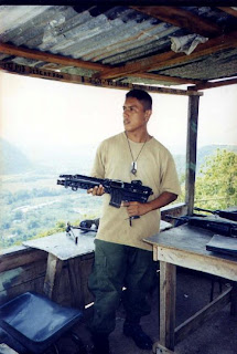
The first time I climbed up the hill it took me 1 hour 15 minutes and I was about to die. There is a very narrow path you follow when you reach the peak of the hill. British Army Engineers leveled part of the peak to create an HLS. There was a rock walled bunker built into the side of the hill facing the border and the bunkhouse was built on the opposite side. It was less than 50 yards across with an observation platform cast on top. There were posts of angled iron supporting about 4 rows of barbed wire around the perimeter. The hill sides around the OP were relatively steep with trees growing on all sides. There was also a kitchen where the routine cooking was done.
 Looking down the hill you have two views. The southeast side has the Sarstoon River followed by miles of pasture on the Guatemalan landscape. On clear days you can even make out the Caribbean Sea. On the West side you have the Poptun Highway with the Sebol Road forking out of it smack in the middle of Puerto Modesto Mendez, referred to as PMM. There was an even higher hill behind PMM with a GAF Camp at the base. We could see North up to a bridge with a checkpoint.
On top of the hill the heat was intense with doctorflies and mosquitoes depending on you for survival. Stagging during the day was one soldier at a time. We monitored tankers traveling on the Poptun Highway and logged down each one that passed and the direction they were heading. A report based on the logged observations was sent to the office of the Operations Officer at Price Barracks every evening. The idea is that there is an average number of tankers traveling along the Poptun Highway daily. If the idea is that if the number of tankers going South to North suddenly increased it meant the Guats were stockpiling fuel in Peten and thus preparing for an invasion. Apart from observing tankers we also had to patrol around the hill and clean the border marker which was a small concrete structure at a designated way point marking the southwestern corner of the country.
Top photo shows an aerial view of Cadenas OP approaching from the Southwest. Gazelle is parked on the HLS and Guatemala is on the background. This was during the glory days under British control. Photo below is of myself cleaning my personal weapon on my spare time.


When we did the O.P. there were 2 of us on stag. I spent many an hour overlooking the Guatamalan camp in 1978. Thanks for the information. It's very difficult to find anything about Belize from the time I was there with 1 RHF :)
ReplyDelete